Danish municipalities are raising minimum spot heights in harbour areas. It is not always clear which climate scenario should form the basis. Many municipalities use the recommendations by the Danish Coastal Authority.
Climate change will cause the sea level to rise. The Danish Meteorological Institute estimates a general increase in sea levels of 0.3 to 1 m in Denmark, in this century. Increases will affect the west coast of Jutland and the inner Danish waters.
In addition to the prospect of more and stronger storms, it is likely that, in the future, coastal towns may experience more frequently situations where the sea is forced into harbours and onwards up to low-lying urban areas. Because of heavy downpours, these areas may already be under pressure from surface water flowing from the uplands down to the sea.
Therefore, coastal municipalities are earnestly considering how to safeguard against flooding, amongst other things by setting minimum spot heights. In this regard, it is important to know whether terrain spot heights, basement spot heights, floor spot heights or the spot heights for quays are relevant.
Previous spot heights set by estimates
Many coastal municipalities are currently drawing up master plans which mark out the overall physical guidelines for the development in harbour areas, in order to improve the interplay of these areas with the general urban development. For example the master plan for the harbour in Horsens in East Jutland is currently undergoing consultation.
The plan states:
"The future shape of the harbour area must incorporate the expected rises in sea level. Harbour areas, or parts of areas, must be raised so that the risk of flooding is minimised and so that a dyke is formed to protect the areas behind (.....). Minimum spot heights must also be stipulated."
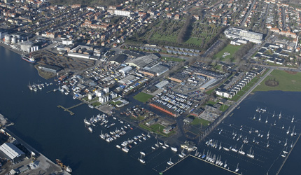
Photo: leisure craft marina in Horsens, November 2008, when the water level was 1.25m above DVR90 (see the fact box for an explanation of DVR90).
Higher quays are not enough
Svendborg, on the southern coast of the island of Funen, is another municipalitiy where the harbour plays an important role for both the public and for the business community(to both public and commercial industry). The harbour not only links to many of the islands in the South Funen Archipelago, it is also a popular destination for amateur sailors. Furthermore, the town of Svendborg stretches right down to the harbour area with hotels, restaurants and other businesses. The Heritage Agency of Denmark has also designated Svendborg harbour as an area of great historical value. The spot height of the quay in Svendborg harbour is today 1.5m, and over the years this has sometimes not been high enough (proven inadequate) to keep back the sea.
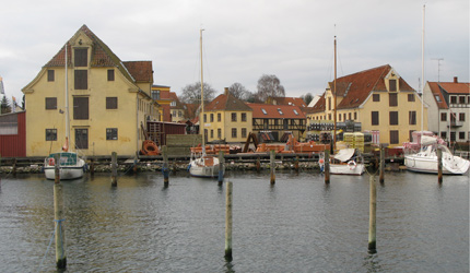
Photo: The town of Svendborg stretches right down to the harbour, and according to the Heritage Agency of Denmark it is an area of great historical value.
Klaus Johannessen from Svendborg Municipality does not think that raising the height of the quay is enough. Alternative solutions should be considered.
"One way could be to design buildings and installations at the harbour so that they can cope with flooding now and then. For example a semi-underground car park or some other functionality which is not sensitive to flooding and which can be emptied quickly. Another model could be to raise areas. However this is not possible in all harbour areas as we have many listed and preservation-worthy buildings. A third model is to establish actual dykes; from large dykes across the sound, like in the Netherlands, to smaller models covering specific parts of the harbour. A combination of different solutions is probably most likely, but as I said, no decision has yet been made", said Klaus Johannessen.
Historically, the height of the quay has always been a practical compromise. In practice, no sailor wants to use a harbour where the quay is so high that it is difficult to load and unload. Getting on board is also difficult with a high quay. The result is that buildings and equipment in harbour areas have to tolerate getting wet now and then.