Climate change impact on plan
In relation to climate change adaptation, spatial planning pursuant to the Danish Planning Act is a management tool which can help curtail certain negative effects of climate change adaptation measures, and which, in the long term, might also help us exploit the positive effects, where these relate to future use and development of the land.
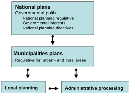
The Danish planning legislative system
Denmark is divided into urban zones, summer cottage areas and rural zones. The rural zone covers the open countryside and a large proportion of villages and hamlets. Rural zone provisions are intended to prevent uncontrolled development and construction in the open countryside and to preserve valuable landscapes and farmland. New development, changes in land use etc. in urban zones and in summer cottage areas must be in accordance with current local development plans (local plans).
The municipal council is responsible for carrying out comprehensive municipal planning, which must take place within the framework of state spatial planning provisions given in national planning directives. Similarly, local plans must be in accordance with the municipal development plan (the municipal plan) and any national planning directives.
Via the legally binding provisions (national planning directives), the Minister for the Environment can also influence the municipalities' planning through political statements in the national planning report, which is to be prepared after early elections to Folketinget (the Danish Parliament), and through "the overview of national interests in municipal planning" which, according to the Planning Act, is to be published every four years for use in the municipalities' revision of municipal development plans.
Furthermore, the Minister has specific powers to intervene in local planning to ensure national interests. These powers include in particular the Minister for the Environment's power to make objections against proposed municipal development plans on behalf of all state bodies whose interests are influenced by the municipal plan. Adaptation of new land use, for example in connection with adaptation to climate change, could fall under the concept of national interests.
Climate change in spatial planning
Cities and buildings etc. that are to last 50-100 years or more will be severely hit by climate change. Therefore, it is important to take account of climate change adaptation already in the planning phase.
Many municipalities have taken climate change adaptation into consideration in their municipal plans or have prepared separate climate change adaptation plans.
The most important climate changes with regard to planning are rising water levels, increased precipitation and increasing temperatures.
Planning in the coastal zone
Almost half of Denmark's population lives less than 3km from the Danish coastline, which measures 7,400km. A 15cm to 75cm sea-level rise within this century will increase the risk of flooding and erosion along the coastline.
According to the Danish Planning Act, special considerations must be taken in the coastal zone.
- Only in very special cases may construction works which require special coastal protection be sited on land.
- The municipal plan must include the assumptions on which the plan is based and the future development in the coastal zone, including which areas will be kept clear of buildings.
In local plans the municipalities may require that buildings be placed in specific areas or at a certain terrain height in order to take account of rising sea levels. The municipalities may also require that certain areas be kept clear of buildings to make room for the dynamics of nature.
Individual plot owners are responsible for building or maintaining dikes or other coastal protection. In many areas, property owners have united in dike associations in order to manage this task jointly. Coastal protection requires approval from the Danish Coastal Authority.
The Danish state is considering increasing the current height of the foundation walls by 0.7m in order to take account of future water-level increases.
Planning for precipitation
Buildings in low-lying areas are vulnerable to sudden cloudbursts which could overburden sewer systems. In recent years, many people have seen roads and their basements flooded.
To take some of the load off sewers, the area of hard surfaces can be reduced allowing more rainwater to seep down into the soil.
Along watercourses space can be made for meanders or wetlands. This delays the water and makes controlled flooding possible in connection with high water levels.
Businesses and individuals
The individual citizen or enterprise can reduce the pressure on sewer systems locally by:
ensuring that rainwater can percolate through the soil;
ensuring water collection, which can then either be added to sewer systems later or used alternatively (for watering gardens, greywater, etc.);
ensuring the water can run into lakes, wither existing or reconstructed.
The municipalities
The municipalities can design guidelines for designating areas as urban zones or as summer cottage areas in the municipal plan. In this connection, topographical and geological conditions may be taken into consideration, so that water may percolate down and be led away.
In connection with urban regeneration projects, plans can be made for diverting surface water to detention basins which can be included in an overall urban architectural whole.
In local plans, topographic dips can be kept clear from new development. Requirements may be set up for local rainwater percolation or for rainwater collection from roofs for use in toilet flushing and clothes washing as a condition for taking into use new buildings.
Planning for higher temperatures
Higher temperatures in cities will increase the demand for shaded spaces where people can stay when the temperature is at its highest. Many urban spaces, parks, squares and streets, may be improved by establishing basins, permanent installations or vegetation.
The need for cooling in connection with new buildings is met by constructing cool roofs that reflect sunlight or green roofs (or 'living' roofs) that absorb rainwater and lower air temperatures.
Warmer and dryer summers will mean a greater need for watering and irrigation. For this reason, too, it is important that rainwater is allowed to percolate rather than being led directly out into the sea via the sewer systems.
As a process tool, the Danish Planning Act offers several opportunities for involving different aspects in relation to climate change and temperature increases, both in municipal and local planning.