In Aarhus water from heavy rainfall is being channelled to a new lake. The lake also reduces nitrogen leaching from surrounding agriculture. The city is now seeking to extend the project and create another wetland.
Climate change
implies more intense cloudbursts and rising sea levels, making the
provision of flood protection for low-lying and densely populated
areas increasingly urgent. An inexpensive and intelligent
solution to these problems is to use natural areas as a "buffer" to
hold water during and after extreme rainfall events and at high
tide. Egåedal is an example of this type of water body.
The valley of Egå
Close to
Aarhus, the second largest city in Denmark, the southern part of
the Egådal is densely populated, low-lying and at risk of flooding
under increased precipitation.
From the
1950s, the area was the object of extensive drainage to gain more
land for agricultural purposes. Two pumping stations were
established at the old natural steam, Egå, in order to pump water
out of the wetland and into a new channel that carried it to Aarhus
Bay. After this, intensive farming dominated the Egå valley.
Today the
stream has been partly restored to its natural state and represents
an example of adaptation to climate change that has had multiple
benefits.
A lake
is created
When it was
realised that intensive farming and leaching of nitrogen in
particular had negative consequences on animal and plant life. the
Danish parliament adopted the Action Plan for the Aquatic
Environment II in 1998. Its purpose was to reduce nitrogen leachate
to the aquatic environment. One of the means to achieve this was to
restore original streams and wetlands.
Thus began a
collaborative project involving the municipality of Aarhus and
other related institutions with the aim of applying the Action Plan
for Aquatic Environment II in the Egå valley. Chosen areas were
expropriated and a dam was established. In 2006 the old stream
dykes were removed and about half of the previously reclaimed area
was flooded. The result was Egå Engsø, a lake of 115 ha. with a
mean depth of approximately one metre and 1.7 metre its
deepest. The water level can be raised by about one metre
depending on seasonal and rainfall conditions.
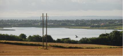 Figure 1: Photograph of the
established Egå Engsø.
Figure 1: Photograph of the
established Egå Engsø.
Egå
Engsø affords both space and time for achieving a water
balance
A dynamic flow
model for the area has been produced by the company Orbicon. The
model shows that the lake has reduced the flood risk of the densely
populated areas in the lower part of the river valley and along
Egå. This is because Egå Engsø acts as a holding lake, slowing
runoff when there are heavy or prolonged rainfall events. This
helps reduce high water levels downstream, but also extends the
period during which the water table is slightly raised.
Egådalen remains at risk of flooding
Egådalen is a
characteristic landscape element, and is very low-lying in
comparison with the surrounding terrain. Figure 1 shows a
terrain model illustrating the extent of the Egå valley and the
low-lying areas.
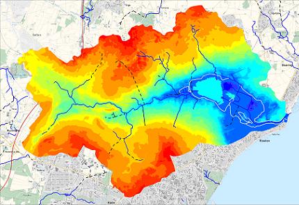
Figure 2: Terrain model of Egådal
catchment area. The former area of reclaimed land is outlined
with a white line. The colours on the map show terrain
elevation, with blue lowest and red highest. The restored lake from
2006 appears turquoise in the low-lying area.
The
low-lying areas in the bottom of Egådal near Risskov are at risk of
flooding, either through intense runoff from uplands or at high
tide in Aarhus Bay. Currently, the area is protected by levees
and a pumping station at the Egå mouth in Aarhus Bay.
The lake's holding capacity is reduced if the water level in the
lake is already high at the onset of a heavy rainfall
event. In 2007 rainfall during January, February and March was
significant and lakes, streams and ground water were at maximum
capacity. Furthermore early March saw a large amount of snowmelt,
which exacerbated the danger. This resulted in the highest
sustained water flow rates in 10 years and the Egå was close to
bursting its banks. Emergency response units from all over
Denmark were called to the area to prevent a flood that could have
had major economic consequences. The event highlighted the need for
further preventive measures.
An investigation in 2008 recommended the incorporation of the
remaining reclaimed land in the Egå valley to enhance the holding
capacity and reduce flood risk from extreme rainfall
events.
Adaptation potential for a new wetland
The Aarhus
municipal plan has designated the remaining reclaimed land areas as
"possible future wetlands". This is an excellent basis on which to
plan the establishment of a new wetland.
Figure 2 shows the proposed wetland area marked with red
line. The proposed area is located immediately downstream of
the current Egå Engsø and will thus enhance the storage
effect.
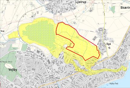
Figure 2: the yellow area is Vejlby-Egå
Enge reclaimed land and the red line marks the boundary for a
further proposed wetland, called Hede Enge (heath
meadows).
A new wetland
will serve several purposes, including:
-
reduction in nitrogen leaching into the Bay of
Aarhus
- further
reduction of the risk of flooding in the lower part of the Egå
system through attentuation
- improvement
in the natural environment by ensuring environmentally-conscious
land management
- improvement
in recreational opportunities in conjunction with Egå Engsø.
The new wetland is therefore unique as a climate change adaptation
project. Calculations show that it could hold large volumes of
water from a downpour lasting half to one day in a controlled flood
zone, thereby reducing the risk of flooding of many homes along the
lower Egå.
Regulations
Because of an
EIA-screening prior to the project, Engsø did not require an
environmental impact assessment (EIA) before the project could be
launched in 2006. It seems likely therefore that flooding the
adjacent area will not require an EIA.
The actual execution is relatively simple, but requires
appropriate coordination to ensure that the many interests and
concerns are taken into account. Before the project can be
initiated, it must be approved in accordance with relevant Danish
environmental acts.
As the area is part of an existing land reclamation area, rules
and agreements must be established for the administration of the
project. The project in Egå Engsø and the plans to extend the
wetlands with a new lake therefore require that a sharing of costs
between private landowners and government be
considered.
Costs
A large portion of the costs relate to compensation for affected
landowners for expropriation of land. The cost of constructing
Egå Engsø in 2006 was DKK 20 million, VAT excluded. The
cost of the proposed project at Hede Enge is estimated at
approximately DKK 25 million, of which 80 per cent is for
compensation to landowners.
Similar
reclaimed land can be found at many other locations in Denmark, and
the work in Aarhus can therefore serve as a pilot project in terms
of climate adaptation in the water sector.