The Danish municipality of Hedensted is in the process of tackling the problems already caused by a changing climate while at the same time safeguarding against future climate change.
The municipality of Hedensted in eastern Jutland is very close to
the perfectly average Danish municipality. Almost 540 square
kilometres of good farmland in the midst of eastern-Jutland's
growth zone between Horsens and Vejle support the municipality's
ambition of being 'a rural municipality in growth'. A long and
beautiful stretch of coast facing the Little Belt and Vejle Fjord
provides the municipality's 45,000 inhabitants with added amenity
value as well as holiday homes which bring business to the
outskirts of the municipality.
From a climate point of view, the municipality is also typical:
During heavy rainfall the small river Gesager Å, which passes west
of Hedensted town, often floods, and in the town itself, the
rainwater has nowhere to run off and therefore causes flooding in
parts of the city. An area with holiday homes is in danger of
flooding when the sea level off the coast increases after a storm,
and in the harbour town of Juelsminde, the dike protecting the city
is in need of inspection and maybe also extension, perhaps with
extra coastal defence works.
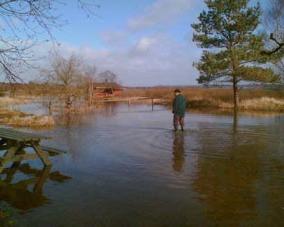
Many holiday homes will be exposed to high water levels in the
future. Even more will be exposed during extreme weather events.
Furthermore, access to and use of beach areas in general will
become more difficult.
Climate change adaptation is incorporated into
plans
So Hedensted is really not that different from other Danish
municipalities. However, when it comes to further work on
safeguarding the municipality's buildings, homes, green areas, etc.
against a changing climate, the municipality is at the forefront.
This year, the municipality will adopt its first 'climate-adapted'
municipal plan.
The municipal plan is the general plan for development in the
municipality during the next twelve years. The plan is adjusted
every four years, and for the first time climate developments have
been incorporated in the version of the plan to be adopted by the
end of 2009, so that all future construction works and land-use
designations take account of more precipitation, rising sea levels
and other predictable climate change impacts.
"We are reversing the process. Today we spend both time and money
on safeguarding infrastructure, buildings and ourselves against the
problems caused by climate change. In future we will make sure that
all new land-use designations, construction projects etc. are sited
and designed in such a manner as to avoid spending resources on
safeguarding them against climate change at a later stage. At least
not for the next hundred years," says Niels Rauff, forestry and
landscape planner in the municipality of Hedensted.
From a practical point of view, it is very much about procuring
knowledge and data about water. How much more precipitation can we
expect over the next hundred years? Where will the water from heavy
downpours collect? How much will the sea level in the oceans rise,
and how high will water levels be along the coast after a storm?
When we know this, we will be able to identify those areas in the
municipality that should by no means be developed. Furthermore, we
can start to look at how sewers and other utilities are to be
designed and sited, and we can start the debate on whether to allow
rainwater to pool in certain areas in certain periods.
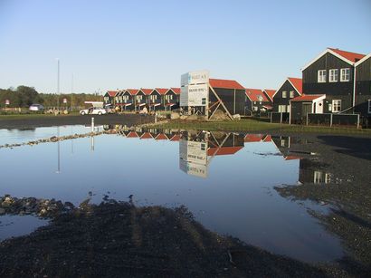
Even newbuilt homes are vulnerable to climate change impacts.
In Juelsminde, water levels reached just 10cm below the floorboards
of these newbuilt holiday homes during the most recent high-water
weather event.
"We often have several things we need to take into account.
If we only had to lead the water away via watercourses and into the
sea as quickly as possible, all we would have to do was dig deeper,
broader and straighter watercourses. But this wouldn't be the
holistic solution that we are striving for; a solution which takes
into account both the volume of water, life in and around the
watercourses as well as the nature experience. So digging
deeper is not an option for us. We must be able to manage the water
and ensure rich and thriving nature," says Niels Rauff.
Difficult but necessary to work together across
disciplines
The basis for the municipality's work is the most recent report
from the UN climate panel, the IPCC. To be on the safe side, the
municipality has chosen the worst scenario from the IPCC's report
and has even added an extra meter to the scenario's sea level
projection.
However, although it seems simple enough on the face of it,
compiling the necessary knowledge and making it useful in practice
has been a huge task. Work began in 2006 with public consultations
about the city's future. Climate change adaptation was not a part
of the original basis, but contributions from the public changed
the municipality's vision of growth to signify growth in quality of
life and in opportunities for expression and experience. This made
it natural to think of both safeguarding against climate change and
safeguarding a good and exciting environment for the
municipality.
"On the other hand, we discovered that is
crucial when it come to adapting to climate change. And cooperating
across specialist fields is not an easy task. It requires constant
attention to whether everyone is participating, whether they have
the same goal, and what can be done if this is not the case," says
Niels Rauff.