Climate change impact on coasts
The Danish coastline comprises active coastal cliffs where the sea erodes material, as well as beach-ridge complexes where material is deposited in the lee of prevailing winds. About 80% of the Danish population lives in urban areas near the coast. A total of about 1800km of coastline is protected by dykes or other types of coastal protection.
Low-lying areas are especially at risk, since they are both exposed to increases in sea level and are under pressure from increasing surface runoff from land areas. In particular, many of the coastal towns near larger river estuaries or at the bottom of fjords may face complex problems. Merely building higher dykes, for instance, is not a long-term solution, as the problem of backwater flooding will just become greater as a result of river water being unable to flow freely into the sea. A long-term solution requires the involvement of river valleys further inland.
Water level
The tide varies from hour to hour along the coast. In winter time, the water level and waves are higher because it is generally more windy during winter.
The Danish Coastal Authority prepares statistics of the probability of a given extreme water level throughout Denmark. These statistics are for use in coastal development planning and in the design of coastal defences.
The statistics are based on the water-level gauges which have been set up along Danish coasts, typically in harbours. These coastal water-level gauges are managed by harbours, municipaliteis, the Danish Meteorological Institute and the Danish Coastal Authority. To obtain good statistics, it is esential that the water-level gauges are calibrated on a regular basis. The statistics are updatede approximately every five years last in 2017.
Risk of Flooding
When water levels generally increase due to climate change, the probability that a given water level will occur increases as well. How much depends on the location.
In addition to rising sea levels, climate change will also lead to increased precipitation and more extreme downpours in winter. The majority of this precipitation will end up in rivers and watercourses. This will further increse the risk of flooding of coastal areas adjacent to the estuaries of rivers and watercourses.
Planning and development
Climate change should be incorporated when planning the development of coastal areas, when this involves buildings and installations with long life spans, i.e. where climate change will have significant impacts on the buildings or installations during their useful lives.
The Coastal Planner
The Danish Coastal Authority has prepared a national risk map of Danish coastal areas up to 2020 supplemented by suggested strategies and poroposals for specific initatives to manage flodod and erosion risks.
When planning the development of flood-prone areas, it is important to realise that the problem not much a rising sea, but rather insufficient terrain height, as illustrated below.
The illustration shows a situation where development is planned for the area behind a dyke. Two water levels must be taken into account here: the level of the sea in front of the dyke and level of the watercourse behind the dyke. Both levels are indicated by light blue. When the sea level rises and precipitation increases, the risk of flooding grows as well.
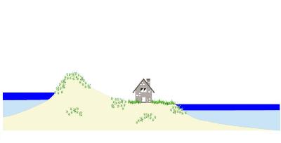
This challenge can be met in different ways. An obvious solution would be to decide that the area should not be developed for housing purposes and that the houses should be built on higher ground.
Another possibility would be to increase the terrain height by feeding the area with more sand. The terrain height could be adjusted to the desired level of security against floods. The level of security could be based on an assessment of the life span of the buildings; for example one hundred years' security.

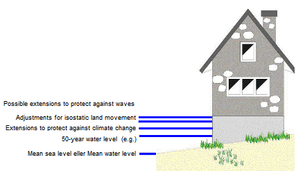
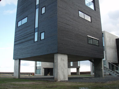
A third possibility would be to construct the houses on foundations that are high enough to ensure the desired level of security against floods. The illustration below shows the extensions which should be considered when determining the foundation elevation of a house. When determining the extensions, several scenarios should be used to examine the vulnerability to climate change. The foundation may be designed in a traditional manner or the house may be constructed on piles or similar.
Senest redigeret:
22-11-2022