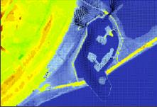
Two-dimensional hydrodynamic surface model
A hydrodynamic surface model can be coupled with a 2D surface
model to provide a more accurate image of the dynamics of surface
runoff in extreme rainfall events. A 2D surface model can describe
surface runoff more precisely than a 1D model, but it is also
considerably more calculation-intensive. The most common input data
for the surface models are elevation models based on aerial surveys
or other detailed elevation models with grid sizes between 1 and
4m. The surface model is adjusted using polygons for houses, roads,
etc., included at their physically correct location in the
model.

Senest redigeret:
05-02-2014